Search This Blog

Monday 11 November 2013

TSUNAMI


TSUNAMIS

KILLER WAVES


Photo: Great Nicobar Island after tsunami


tsunami is a series of ocean waves that sends surges of water, sometimes reaching heights of over 100 feet (30.5 meters), onto land. These walls of water can cause widespread destruction when they crash ashore.
These awe-inspiring waves are typically caused by large, underseaearthquakes at tectonic plate boundaries. When the ocean floor at a plate boundary rises or falls suddenly it displaces the water above it and launches the rolling waves that will become a tsunami.
Most tsunamis, about 80 percent, happen within the Pacific Ocean’s “Ring of Fire,” a geologically active area where tectonic shifts make volcanoes and earthquakes common.
Tsunamis may also be caused by underwater landslides or volcanic eruptions. They may even be launched, as they frequently were in Earth’s ancient past, by the impact of a large meteorite plunging into an ocean.
Tsunamis race across the sea at up to 500 miles (805 kilometers) an hour—about as fast as a jet airplane. At that pace they can cross the entire expanse of the Pacific Ocean in less than a day. And their long wavelengths mean they lose very little energy along the way.
In deep ocean, tsunami waves may appear only a foot or so high. But as they approach shoreline and enter shallower water they slow down and begin to grow in energy and height. The tops of the waves move faster than their bottoms do, which causes them to rise precipitously.
A tsunami’s trough, the low point beneath the wave’s crest, often reaches shore first. When it does, it produces a vacuum effect that sucks coastal water seaward and exposes harbor and sea floors. This retreating of sea water is an important warning sign of a tsunami, because the wave’s crest and its enormous volume of water typically hit shore five minutes or so later. Recognizing this phenomenon can save lives.
A tsunami is usually composed of a series of waves, called a wave train, so its destructive force may be compounded as successive waves reach shore. People experiencing a tsunami should remember that the danger may not have passed with the first wave and should await official word that it is safe to return to vulnerable locations.
Some tsunamis do not appear on shore as massive breaking waves but instead resemble a quickly surging tide that inundates coastal areas.
The best defense against any tsunami is early warning that allows people to seek higher ground. The Pacific Tsunami Warning System, a coalition of 26 nations headquartered in Hawaii, maintains a web of seismic equipment and water level gauges to identify tsunamis at sea. Similar systems are proposed to protect coastal areas worldwide.
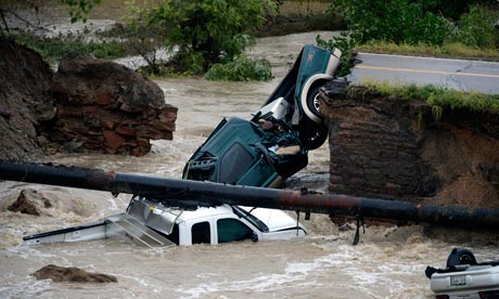


TSUNAMI IN JAPAN


RESULTS OFF THE TSUNAMI


Source: National Geographic

Name: Chen Carmen
Class: 7 Kappa

Typhoon Haiyan: Philippines destruction 'absolute bedlam'

The head of the Red Cross in the Philippines has described the devastation caused by Typhoon Haiyan as "absolute bedlam".

Officials estimate up to 10,000 people have died in Tacloban city and elsewhere. Hundreds of thousands of people are displaced.

Rescue efforts are being hindered by damage to roads and airports.

The storm has now made landfall in north Vietnam, near the Chinese border, but has weakened to a tropical storm.

One of the most powerful storms on record to make landfall, Haiyan - named "Yolanda" by Filipino authorities - barrelled into the eastern coastal provinces of Leyte and Samar on Friday.

It then headed west, sweeping through six central Philippine islands.

Destroyed houses hit by Typhoon Haiyan in the town of Guiuan in Eastern Samar province, central Philippines on 11 November 2013

Almost 630,000 people have been reported displaced.

 More than nine million people have been affected in the Philippines. Many are now struggling to survive without food, shelter or clean drinking water.

  • The exposed easterly town of Guiuan, Samar province - population 40,000 - is said to be largely destroyed

  • Tacloban, Leyte province, was largely flattened by a massive storm surge and scores of corpses are piled by the roadside, leaving a stench in the air as they rot, say correspondents. Hundreds of people have gathered at the airport desperate for food and water, others trying to get a flight out

  • Disaster worker Dennis Chong told the BBC that assessments in the far north of Cebu province had shown some towns had suffered "80-90% damage"

  • Baco, a city of 35,000 in Oriental Mindoro province, was 80% under water, the UN said

  • For more informations, click here > http://bbc.in/1dXd7IA

    Jamie Tay
    7 Kappa :)


    Phillippines Earthquake

    The quake happened at 00:12 on a national holiday. It struck below the island of Bohol.

    DEATHS
    • At least 93 people have been reported after a magnitude 7.2 earthquake hit the central Philippines.
    • There were also deaths in the province of Cebu.
    • 69 of the 93 people were confirmed dead from Bohol.
    • 15 people were killed in Cebu.
    • Many others are treated for injuries.
    • At least 5 people from died when part of a fishing port collapsed in Cebu.


    RESCUE
    • Search and rescue operations are being conducted, with rescuers finding themselves hampered by damaged roads.

    REPONSE
    • " There was a panic when the quake happened and there was a rush towards the exit."
    •  Officials from Bohol and Cebu have declared a state of emergency in their respective provinces.
    •  Strongest tremor felt in the area for the last 23 years.
    The collapsed facade of the San Pedro y San Pablo church in Loboc town, Bohol province
    7.2 earthquake

    Residents walk along huge cracks in a road after an earthquake struck Bohol province, central Philippines, October 15, 2013.
    Huge crack in the centre of a road in Bohol.


    Workers use a crane to lift up concrete block that fell on a car after buildings collapsed during an earthquake in Cebu city, central Philippines, 15 October 2013
    Damage in the neighbouring Cebu.

    Hospital patients are evacuated after an earthquake struck Cebu city, in central Philippines 15 October 2013
    Evacuation

    Rescuers shift through the rubble to recover an unidentified man at a fish port in Pasil, Cebu, central Philippines, 15 October 2013
    Part of the port building collapsed


    If you are busy doing geography work and have no time to read the news then just scroll through this. I took it from the BCC online news website. Enjoy!!

    Name: Soh Jing Wen
    Class: 7 Kappa

    Nile River

    • Longest river in the world
    • Stretches throughout Africa
    • Drainage basin covers 10% of Africa
    • Source is Lake Victoria


    TRIBUTARIES

    Atbara river

    •  Located below the confluence of Blue Nile
    • Source: north of Lake Tana
    • Only flows when there is rain in Ethiopia which dries very fast

    Blue Nile

    • 1400 kilometres long
    • Provides 59% of the water in River Nile
    • Source: Ethiopia
    • Largest tributary

    Yellow Nile

    • Former tributary connecting the Ouaddai Highlands of eastern Chad to the Nile river valley
    • Remains are known as Wadi Howar

    Hope you learn something!!

    Name: Soh Jing Wen
    Class: 7 Kappa


    Employment structure in Uk


                                                                                                                                                     Arif


    Parts of river


                                                                                                                                                       Arif

    Thursday 3 October 2013

    Prevailing Winds

    Prevailing Winds => Directions where the wind is likely to come

    Prevailing Winds in Britain from the South bring warm weather, whilst winds from the North brings cold weather.

    Tropical Maritime
    Source => Atlantic ocean/ Bermuda Triangle

    Characteristics
    1)Large amount of moisture
    2)Bring warm weather to UK

    Tropical Continental
    Source=>Africa (deserts)

    Characteristics
    1)The wind that blows to Southwest England does not bring normal rain, it brings orange rain (carries dust from Sahara desert) 

    Polar Continental (cold and dry) 
    Source=> Scandinavia/Russia

    The distance from source to UK is short therefore not much rainfall is brought. 

    Winters=>Very cold, brings snow
    Summer=>Warm, stable condition

    Arctic Maritime 
    Source=> Atlantic Ocean

    Winters and Springs=> Cold condition

    Duration of agriculture of the land that this winds blow to=> Very short

    Main activities of the land that this winds blow to=> Tourism, cattle ranching

    Polar Maritime
    Source=> Canada/ Greenland

    Characteristics
    1)The most common air mass to reach UK
    2) Brings cold conditions through the year 
    3)Brings more rain
    4) Forms clouds
    5) Showers during winter


    Prevailing winds of UK 


    Source: Google images, geo notes  

    Chow Jo Yi 7 Kappa

    Saturday 14 September 2013

    The 1556 Shaanxi Earthquake

    [The reason why this was posted on 14/9 instead of 13/9 was due to internet connection problems]

    The Shaanxi earthquake in China was a catastrophic earthquake and is also the deadliest eartquake on record, killing approximately 830,000 people. More than 97 countries in the Shaanxi province were affected, this includes:  Shanxi, Henan, Gansu and many more.

    The earthquakes's epicenter was in the Wei River Valley. 

    Modern research shows that the magnitude is 7.9! It is the most deadliest earthquake and the fourth most deadliest natural disaster in the world. After the earthquake, the aftershocks occured a few times a month for half a year.

    The cost of damage done by the earthquake is almost impossible to calculate with modern technology. The death toll has been eastimated from 820,000 to 830,000. The damage is incalculable as an entire regoin of inner China had been destroyed and more than 60% of the region's population died.


    This picture shows where the earthquake occurred.[The Shaanxi Province]

    The damage done by the earthquake.


    By Khoo Lian Keat, 7 Kappa

    Friday 13 September 2013

    Largest volcano on Earth found, scientists say


    LARGEST VOLCANO ON EARTH FOUND, SCIENTISTS SAY


    (CNN) -- Move over, Mauna Loa.

     A group of scientists say they've found a volcano bigger than you.

     Way bigger.

     An underwater volcano dubbed Tamu Massif was found some 1,000 miles east of Japan, says William Sager, a professor at the University of Houston, who led a team of scientists in the discovery.

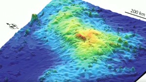
    World's largest volcano discovered

     The volcano is about the size of the state of New Mexico and is among the largest in the solar system, Sager says.

      Tamu Massif covers an area of about 120,000 square miles. In comparison, the largest active volcano on land, Hawaii's Mauna Loa, is about 2,000 square miles, Sager says.

      "Its shape is different from any other sub-marine volcano found on Earth, and it's very possible it can give us some clues about how massive volcanoes can form," Sager says.

      Tamu Massif is believed to be about 145 million years old, and became inactive within a few million years after it was formed.

      The volcano was partly named in honor of Texas A&M University, where Sager worked for 29 years before moving to the University of Houston. Tamu is the university's abbreviation while massif is the French word for "massive" and a scientific term for a large mountain mass, according to Sager.


    Prepared by: Harsheni (7 Kappa)

    Date: 13.9.13

    Teacher: Mr Ratanam

    Function of 3 Places in The United Kingdom

    Function of 3 Places in The United Kingdom


    1) London


    • the capital of United Kingdom
    • a major international finance centre
    • a global city with strengths in the arts, commerce, education, entertainment, fashion, finance, healthcare, media, professional services, research and development and tourism
    • provide many transport services to the public
    • a world cultural capital 

    2) Cambridge


    •  a university town and the administrative centre of the county of Cambridgeshire, England.
    • a beautiful countryside-like area
    • very famous for education
    • University of Cambridge is one of the best universities on Earth
    • has many street shops

    3) Liverpool
     
    • city and metropolitan borough of Merseyside
    • important cultural centre
    • football is very famous in this city; home to Everton F.C. and Liverpool F.C.
    • both primary and secondary education are provided in the city
    • very famous for exciting nightlife

    Prepared by: Harsheni (7 Kappa)

    Date: 13.9.13

    Teacher: Mr Ratanam

    1991 Bangladesh cyclone

    The 1991 Bangladesh cyclone was one of the most deadliest tropical cyclones on record. The cyclone happened in 29th April, the cyclone struck Chittagong district of Bangladesh with winds around 250 km/h ( 155 mph ) 

    A picture of the cyclone 

    The storm forced a 6 metre ( 20 ft ) storm surge inland over a wide area .

    Fatalities and Health crisis

    * 138, 000 people were killed ( 25000 dead in Chittagong, 40000 dead in Banshkali and 8000 in Kutubdia )

    * 10 million people were homeless

    * Most death were from drowning

    Even after building a cyclone shelter after the cyclone in 1970 Bhola cyclone, many only had a few hours of warning and did not know were to go. Even so, 2 million people did evacuate from the dangerous area.

    Property Damage

    The caused of the cyclone an estimated $1.5 billion ( 1991 US dollars )
    The high velocity wind and the storm surge devastated coastline. The Karmaphuli River in Patenga was washed away by the storm surge.

    Environmental impact 

    The storm surge subsequently caused the embankment, as well as whole villages, to be swept away. For an additional three to four weeks after the storm had dissipated, mass land erosion resulted in more and more farmers losing their land, and therefore, the number of unemployed rose. In several ares up to 90 percent of crops had been washed away. The shrimp farms and salt industry were left devastated.

    A few deadliest hurricanes

    1) November 1970 - Approximately 150,000-500,000 deaths - Bhola Cyclone - Bangladesh (at the time East Pakistan).
    2) April 1991 - Approx. 131,000-138,000 deaths - Bangladesh.
    3) May and June 1965 (two cyclones) - Approx. 60,000 deaths - Bangladesh (at the time East Pakistan).
    4) October 1942 - Approx. 40,000 deaths - Bangladesh/India border (at the time all India).
    5) May 1963 - Approx. 22,000 deaths - Bangladesh (at the time East Pakistan).
    6) November 1977 - Approx. 10,000-20,000 deaths - Andhra Pradesh Cyclone - India.
    7) October-November 1998 - Approx. 11,000-18,000 deaths - Hurricane Mitch - Central America.
    8) September 1971 - Approx. 10,000 deaths - Orissa Cyclone - India.
    9) October 1999 - Approx. 10,000 deaths - Cyclone 05B - India.
    10) September 1900 - Approx. 8,000-12,000 deaths - Galveston, Texas, United States.

    Done by : Lam Hoc Sing  7 kappa 
    Sectors of the Economy
     
    There are 4 types of sectors :
    Primary
    ~ Secondary
    Tertiary
    Quaternary
     
     
    Primary Sector
    - The primary sector of the economy extracts or harvests products from the earth.
    - The primary sector includes the production of raw material and basic foods.
    - Activities associated with the primary sector include agriculture (both subsistence and      commercial),mining, forestry, farming, grazing, hunting and gathering, fishing, and quarrying.
    - The packaging and processing of the raw material associated with this sector is also considered to be part of this sector.
    - In MEDC's, the number of primary workers are rapidly decreasing.
    - In LEDC's, the number of primary workers remains the same.
     
     
    Secondary Sector
    - The secondary sector of the economy manufactures finished products.
    - All of manufacturing, processing, and construction lies within the secondary sector.
    - Activities associated with the secondary sector include metal working and smelting, automobile production, textile production, chemical and engineering industries, aerospace manufacturing, energy utilities, engineering, breweries and bottlers, construction, and shipbuilding.
    - Many of these industries consume large amounts of energy and require factories and machinery to convert the raw materials into goods and products.
    - They also produce waste materials and waste heat that may pose environmental problems or cause pollution.
     
    Tertiary Sector
    - The tertiary sector of the economy is the service industry.
    - This sector provides services to the general population and to businesses.
    - Activities associated with this sector include retail and wholesale sales, transportation and distribution, entertainment (movies, television, radio, music, theatre, etc.), restaurants, clerical services, media, tourism, insurance, banking, healthcare, and law.
    - In MEDC's, the number of tertiary workers are gradually increasing.
    - In LEDC's, there are very little tertiary workers.
     
     
    Quaternary sector
    - The quaternary sector of the economy consists of intellectual activities.
    - Activities associated with this sector include government, culture, libraries, scientific research, education, and information technology.
    - There are some quaternary workers appears in MEDC's.
    - There are almost none quaternary workers in LEDC's.


     Primary Sector


                                                                   Secondary Sector
     
     Tertiary Sector


    Quaternary Sector
     
    Reference
     
     
     Jamie Tay
    7 Kappa
    Thanks for reading :D


    Functions of 3 Places in UK

    Function of 3 Places in UK 


    1)  Liverpool       


    • Liverpool is a city and metropolitan borough of Merseyside, England, United Kingdom along the eastern side of the Mersey Estuary.
    • As with other large cities, Liverpool is an important cultural centre within the United Kingdom, incorporating music, performing arts, museums and art galleries, literature and nightlife amongst others.
    •  Football is the most popular sport in the city, home to Everton F.C. and Liverpool F.C..
    • In Liverpool primary and secondary education is available in various forms supported by the state including secular, Church of EnglandJewish, and Roman Catholic
    • At the 2011 UK Census the recorded population of Liverpool was 466,400


    Between 2001 and 2006 it experienced the ninth largest percentage population loss of any UK unitary authority

    2) Oxford


    • Oxford is a city in central southern England. 
    • It is the county town of Oxfordshire, and forms a district within the county. 
    • It has a population of 150,200 ,  and lies within the Oxford metropolitan area with a population of 244,000.
    • The University of Oxford is the oldest university in the English speaking world and one of the most famous and prestigious higher education institutions of the world
    • Oxford city centre has many shops, several theatres, and an ice rink.


    3) Plymouth


    • is a city and unitary authority area on the south coast of Devon, England, about 190 miles (310 km) south-west of London.
    • It is situated between the mouths of the rivers Plym to the east and Tamar to the west, where they join Plymouth Sound.
    • The University of Plymouth is the 9th largest university in the United Kingdom by total number of students
    • From the 2011 Census, the Office for National Statistics published that Plymouth's unitary authority area population was 256,384.


      Done by : Tor Jia Wen , 7 Kappa ! (:


      Two roadside bombs outside mosques kill 30 in Baquba...

      BAQUBA, Iraq  - Two roadside bombs exploded outside a mosque in the Iraqi city of Baquba killing 30 people, as Sunni Muslim worshippers were leaving following Friday prayers, police said.
      A further 25 people were wounded in the blasts, which went off in quick succession. The second tore through a crowd of people who had rushed to help those hurt in the first.
      It was not immediately clear who carried out the attack.
      More than two years of civil war in neighbouring Syria have brought sectarian tensions in Iraq and the wider region to the boil.
      About 800 Iraqis were killed in August, according to the United Nations, with more than a third of the deadly attacks happening in Baghdad.
      The bloodshed, one-and-a-half years after U.S. troops withdrew from Iraq, has raised concerns about a return to the sectarian slaughter of 2006-07, when the monthly death toll sometimes topped 3,000.

      PREPARED BY: CHEN CARMEN, 7 KAPPA

      IS TECHNOLOGY GOOD?
      Well, good in some extend......

      This is a shocking news technology has created:
      A Chinese woman has been killed by her iPhone, the 23 year old died after she was electrocuted when she answered her iPhone. The phone was plugged into the wall charging at the time, when the lady named as Ma Ailun answered the call. This was reported on the 16th of July.


      According to Ma Ailun brothers, the handset had been bought from an official iPhone store and was not a fake device. He said that the device had been to Chinese authorities for examination.

               There are many fake handsets and chargers on sale in China, with many faults which could be dangerous.

               Many people were alerted to the former flight attendants death who was due to be married later on in the year when her sister posted a warning on the internet:
      ‘Ma collapsed and died, while using her charging iPhone I want to warn everyone else not to make phone calls when your mobile phone is recharging,’
      The news spread like wildfire across the internet, which is thought to be another blow to Apples reputation in China and the world after numerous bad press articles.

              There are a number of theories on why poor Ma Ailun was electrocuted through her iPhone, including a faulty charger, poor wiring in her home and excessive temperatures damaging wires, although death by electrocution from a charging phone is extremely rare.
      Apple said in a statement: “We are deeply saddened to learn of this tragic incident and offer our condolences to the Ma family. We will fully investigate and co-operate with authorities in this matter.”


      So, is technology always good anymore, not these days when there are fake items being sold outside the world. Still think technology is good? Well, think again.......

      Done sincerely by Justin Liew ,7 Kappa

      Colorado flooding leaves three dead


      Residents flee to higher ground as record monthly rainfall prompts flash floods and inundates towns and cities

      Colorado floods
      Three vehicles rest in floodwater after a crash near a washed away road at Dillon, Colorado. No one was seriously injured. Photograph: Andy Cross/AP

      Flooding that left at least three people dead in Colorado worsened overnight as record rains pounded the state, forcing thousands more residents to flee to higher ground, officials said.
      The unusual late-summer downpours drenched Colorado's biggest urban areas, stretching 130 miles along the eastern slopes of the Rockies from Fort Collins near the Wyoming border south through Boulder, Denver and Colorado Springs.
      In Boulder, the rainfall record for September set in 1940 was shattered, officials said, unleashing floodwaters in Boulder Canyon above the city that triggered the evacuation of 4,000 residents on Thursday.
      "There's so much water coming out of the canyon, it has to go somewhere, and unfortunately it's coming into the city," said the Boulder office of emergency management.
      Boulder Creek, which runs through the city, burst its banks and flooded adjacent car parks and streets. Other towns nestled along the Front Range of the Rockies north of Denver were also hit.
      Barack Obama approved a federal disaster assistance request. National Guard troops were dispatched to the remote town of Lyons, north of Boulder, which was virtually cut off from surrounding areas.
      A dozen major roads in north-eastern Colorado remained shut with significant damage from flooding, mudslides, rockfalls and other debris, the Colorado department of transportation said.
      Heavy summer rains are not unusual for Colorado, but the intensity and duration of the downpour that began on Monday night was unprecedented.
      The National Weather Service said at least 12.3 inches (31 cms) of rain had fallen on Boulder since 1 September, more than double the 63-year-old monthly record.
      One body was found in a collapsed building near Jamestown, an evacuated enclave north of Boulder. A couple were swept away in floodwaters after stopping their car north-west of the city. The man's body was recovered but the woman was missing and feared dead.
      The body of a third confirmed fatality, a man, was found by police on flood-watch patrols in Colorado Springs, about 100 miles south, officials said.
      Nearly 150 people were killed near Boulder in 1976 by a flash flood along the Big Thompson Canyon.

      Where is Colorado?
      It is located in USA.
      Facts of Colorado.
      • Capital City: Denver
      • Location: 39.768N, 104.872W
      • AreaRanked 8th
         - Total104,094 sq mi
        (269,837 km2)
         - Width380 miles (612 km)
         - Length280 miles (451 km)
         - % water0.36%
      • Flag: Click for detailed Colorado Flag
        The flag consists of
         three alternate stripes of equal width and at right angles to the staff, the two outer stripes to be blue of the same color as in the blue field of the national flag and the middle stripe to be white, the proportion of the flag being a width of two-thirds of its length. At a distance from the staff end of the flag of one fifth of the total length of the flag there is a circular red C, of the same color as the red in the national flag of the United States. The diameter of the letter is two-thirds of the width of the flag. The inner line of the opening of the letter C is three-fourths of the width of its body or bar, and the outer line of the opening is double the length of the inner line thereof. Completely filling the open space inside the letter C is a golden disk, attached to the flag is a cord of gold and silver, intertwined, with tassels, one of gold and one of silver. Flag adopted 1911. 
      • Geographic Center: Park, 30 miles northwest of Pike's Peak
      • Highest Point: Mt. Elbert; 14,433 feet, 3rd
      • Lowest Point: Arikaree River; 3315 feet, 50th
      • Motto: Nil sine Numine -Nothing without Providence
      • PopulationRanked 22nd
         - Total5,187,582 (2012 estimate)[1]
         - Density49.3/sq mi  (19.0/km2)
        Ranked 37th
         - Median household income$56,993 (13th)

        Time zoneMountainUTC-07/UTC-06
        AbbreviationsCOColo. US-CO
        Websitewww.colorado.gov

      DONE BY: Brayden Ng Zheng Lin      7 Kappa